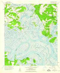
1957 Map of Burroughs
USGS Topo · Published 1959About this map
The coastal wetlands and tidal estuaries of Chatham County are dominated by the winding path of the Ogeechee River and the Little Ogeechee River as they weave through Middle Marsh (Grove River). This mid-century landscape reflects a complex geography of hammock islands and established waterfront communities like Vernonburg and Coffee Bluff. Military and scout presence is significant, marked by the southern edge of Hunter Air Force Base and recreational sites such as Camp Strachan and Camp Low.
Find a feature on this map
51 named features on this map. Tap any name to fly to it.
Don’t see what you’re looking for? This feature index may not catch every label — zoom into the map to look around manually.
Map Details
Editions of this 1957 Burroughs Map
3 editions found
Other maps of this area

1920 · Meldrim
USGS Topo · 1:62,500

1920 · Limerick
USGS Topo · 1:62,500

1942 · Meldrim
USGS Topo · 1:62,500

1942 · Savannah
USGS Topo · 1:62,500

1944 · Limerick
USGS Topo · 1:62,500

1944 · Ossabaw Island
USGS Topo · 1:62,500

1945 · Ossabaw Island
USGS Topo · 1:62,500

1946 · Brunswick
USGS Topo · 1:250,000

1947 · Savannah
USGS Topo · 1:250,000

1948 · Brunswick
USGS Topo · 1:250,000