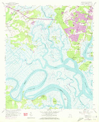
1957 Map of Burroughs
USGS Topo · Published 1973About this map
The tidal landscape of the Georgia coast is captured here during a period of transition, where established riverfront communities meet expanding infrastructure. Fort McAllister stands prominently on the south bank of the Ogeechee River, marking a strategic point where the river bends sharply before reaching Savage Island. To the north, the installation at Hunter Army Airfield and the suburban growth of Windsor Forest signal the mid-century development of the Savannah area, while older settlements like Burroughs and Vernonburg maintain their proximity to the network of waterways including the Grove River and Vernon River.
Find a feature on this map
51 named features on this map. Tap any name to fly to it.
Don’t see what you’re looking for? This feature index may not catch every label — zoom into the map to look around manually.
Map Details
Editions of this 1957 Burroughs Map
3 editions found
Other maps of this area

1920 · Meldrim
USGS Topo · 1:62,500

1920 · Limerick
USGS Topo · 1:62,500

1942 · Meldrim
USGS Topo · 1:62,500

1942 · Savannah
USGS Topo · 1:62,500

1944 · Limerick
USGS Topo · 1:62,500

1944 · Ossabaw Island
USGS Topo · 1:62,500

1945 · Ossabaw Island
USGS Topo · 1:62,500

1946 · Brunswick
USGS Topo · 1:250,000

1947 · Savannah
USGS Topo · 1:250,000

1948 · Brunswick
USGS Topo · 1:250,000