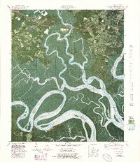
1979 Map of Burroughs
USGS Topo · Published 1988About this map
The tidal marshes and winding river channels of Chatham County dominate this orthophotomap, where the Ogeechee River and Little Ogeechee River converge toward the Atlantic. Along the northern edge, the transition from the runways of Hunter Army Airfield to the suburban expansion of Windsor Forest and Armstrong State College illustrates the late 20th-century growth of the Savannah area. In the lower reaches, the map detail captures the complex hydrology of Middle Marsh and various man-made waterways like the Southfield Canal and Walker Canal. Historically significant sites are scattered throughout the wetlands, including Fort McAllister overlooking the river bends. Settlement patterns are concentrated along high ground, with older communities like Burroughs and Nicholsonville standing alongside country landmarks such as Hawkins Chapel and the Wild Horn Cem.
Find a feature on this map
64 named features on this map. Tap any name to fly to it.
Don’t see what you’re looking for? This feature index may not catch every label — zoom into the map to look around manually.
Map Details
Editions of this 1979 Burroughs Map
4 editions found
Other maps of this area

1920 · Meldrim
USGS Topo · 1:62,500

1920 · Limerick
USGS Topo · 1:62,500

1942 · Meldrim
USGS Topo · 1:62,500

1942 · Savannah
USGS Topo · 1:62,500

1944 · Limerick
USGS Topo · 1:62,500

1944 · Ossabaw Island
USGS Topo · 1:62,500

1945 · Ossabaw Island
USGS Topo · 1:62,500

1946 · Brunswick
USGS Topo · 1:250,000

1947 · Savannah
USGS Topo · 1:250,000

1948 · Brunswick
USGS Topo · 1:250,000