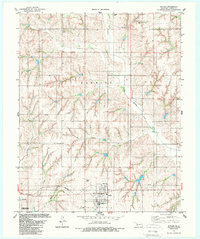
1983 Map of Butler
USGS Topo · Published 1989About this map
Butler serves as the primary hub in this Custer County landscape, situated amidst a network of rural waterways like Barnitz Creek and West Barnitz Creek. The map detail captures the town during the early 1980s, documenting local landmarks including Butler Cem, a sewage disposal pond system, and the town's water tank. An abandoned rail line cutting across the southwest corner near Pitt Creek points to the area's changing transportation infrastructure, while scattered gas wells and drill holes indicate the subsurface energy activity prevalent in this part of Oklahoma.
Find a feature on this map
17 named features on this map. Tap any name to fly to it.
Don’t see what you’re looking for? This feature index may not catch every label — zoom into the map to look around manually.
Map Details
Editions of this 1983 Butler Map
2 editions found
Other maps of this area

1955 · Clinton
USGS Topo · 1:250,000

1957 · Clinton
USGS Topo · 1:250,000

1957 · Butler
USGS Topo · 1:62,500

1960 · Hammon
USGS Topo · 1:62,500

1961 · Leedey
USGS Topo · 1:62,500

1962 · Aledo
USGS Topo · 1:62,500

1976 · Butler NW
USGS Topo · 1:24,000

1976 · Butler NE
USGS Topo · 1:24,000

1976 · Butler SW
USGS Topo · 1:24,000
1976 · Butler SE
USGS Topo · 1:24,000