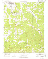
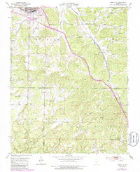
1951 Map of Cabool SE
USGS Topo · Published 1980About this map
Cabool stands as a primary rail hub in the mid-century Ozark landscape, situated at the convergence of the St Louis San Francisco railroad and the Big Piney River. The terrain transitions from the settled valley near town into the densely wooded ridges of the Mark Twain National Forest, which dominates the southern half of the map. This area is characterized by deep hollows like Sterling Hollow and Riley Hollow, where small agricultural clearings and country schools were once the centers of rural life. Notable local landmarks include the Sterling Lookout Tower and a series of rural education sites such as Pea Ridge Sch and the Forest Flower Sch (Abandoned). The placement of Sargent Cem and Jones Cem provides essential grounding for genealogists tracing families in these remote corners of Texas, Douglas, and Howell counties.
Find a feature on this map
38 named features on this map. Tap any name to fly to it.
Don’t see what you’re looking for? This feature index may not catch every label — zoom into the map to look around manually.
Map Details
Editions of this 1951 Cabool SE Map
6 editions found

Other maps of this area

1939 · Topaz
USGS Topo · 1:62,500

1941 · Topaz
USGS Topo · 1:62,500

1945 · Harrison
USGS Topo · 1:250,000

1945 · Willow Springs
USGS Topo · 1:62,500

1945 · Clear Springs
USGS Topo · 1:62,500

1948 · Clear Springs
USGS Topo · 1:62,500

1948 · Willow Springs
USGS Topo · 1:62,500

1949 · Harrison
USGS Topo · 1:250,000

1949 · Rolla
USGS Topo · 1:250,000

1950 · Cabool SW
USGS Topo · 1:24,000