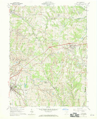
1960 Map of Cadiz
USGS Topo · Published 1970About this map
Industrial extraction and railroad logistics define this portion of Harrison County during the early 1960s. Cadiz and Hopedale serve as the primary population centers, connected by a dense web of competing rail lines including the Pennsylvania and the New York Central railroads. The landscape is heavily marked by extensive strip mines and significant underground operations such as Nelms Mine No 1 and Nelms Mine No 2, reflecting the area's intense coal production. Evidence of an older agricultural and social fabric remains visible in scattered landmarks like Bethel Ch. and several family or community burying grounds, including Mattern Cem and Blue Ridge Cem. Between the ridges and valley floors, the infrastructure of the Pittsburgh And West Virginia line passes through the Rexford Tunnel, while smaller junctions like Folks Siding and Miller Sta. mark the rural transit points of a bygone era of steam and diesel transport.
Find a feature on this map
53 named features on this map. Tap any name to fly to it.
Don’t see what you’re looking for? This feature index may not catch every label — zoom into the map to look around manually.
Map Details
Editions of this 1960 Cadiz Map
4 editions found
Other maps of this area

1901 · Cadiz
USGS Topo · 1:62,500

1902 · Scio
USGS Topo · 1:62,500

1903 · Cadiz
USGS Topo · 1:62,500

1903 · Flushing
USGS Topo · 1:62,500

1904 · Scio
USGS Topo · 1:62,500

1905 · St. Clairsville
USGS Topo · 1:62,500

1905 · Flushing
USGS Topo · 1:62,500

1951 · Canton
USGS Topo · 1:250,000

1953 · Canton
USGS Topo · 1:250,000

1957 · Canton
USGS Topo · 1:250,000