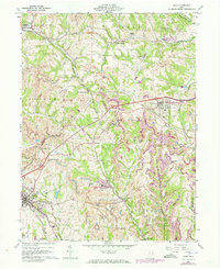
1960 Map of Cadiz
USGS Topo · Published 1973About this map
Industrial activity and rural community life define this portion of Harrison County during the early 1960s. Extensive Strip Mines dominate the topography, illustrating the region's reliance on coal extraction, alongside major subsurface operations like Nelms Mine No 2 and Nelms Mine No 1. The rail infrastructure required to move this tonnage is visible in the paths of the Penn Central, Norfolk and Western, and New York Central railroads which crisscross the landscape.
Find a feature on this map
47 named features on this map. Tap any name to fly to it.
Don’t see what you’re looking for? This feature index may not catch every label — zoom into the map to look around manually.
Map Details
Editions of this 1960 Cadiz Map
4 editions found
Other maps of this area

1901 · Cadiz
USGS Topo · 1:62,500

1902 · Scio
USGS Topo · 1:62,500

1903 · Cadiz
USGS Topo · 1:62,500

1903 · Flushing
USGS Topo · 1:62,500

1904 · Scio
USGS Topo · 1:62,500

1905 · St. Clairsville
USGS Topo · 1:62,500

1905 · Flushing
USGS Topo · 1:62,500

1951 · Canton
USGS Topo · 1:250,000

1953 · Canton
USGS Topo · 1:250,000

1957 · Canton
USGS Topo · 1:250,000