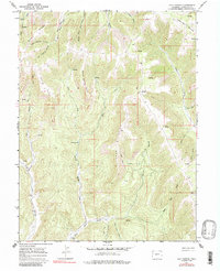
1964 Map of Calf Canyon
USGS Topo · Published 1985About this map
Roan Creek and Salt Creek carve through this high-altitude terrain in the mid-1960s, defining a landscape of deep drainages and prominent ridges. The geography is characterized by expansive plateaus like Pike Ridge and Long Point, which separate complex canyon systems. The area was primarily accessed by a network of JEEP TRAILs and PACK TRAILs, reflecting a period of limited infrastructure focused on grazing and resource management. Notable landmarks include the singular Upper Four A Mountain in the northeast and the isolated Bear Park meadows. Water sources were critical in this environment, as evidenced by the numerous unnamed springs scattered throughout Calf Canyon and Corral Canyon. This survey provides a look at the backcountry of the Western Slope before modern development, capturing the essential drainage patterns of the Williams Fork and East Salt Creek.
Find a feature on this map
29 named features on this map. Tap any name to fly to it.
Don’t see what you’re looking for? This feature index may not catch every label — zoom into the map to look around manually.
Map Details
Editions of this 1964 Calf Canyon Map
3 editions found
Other maps of this area

1956 · Grand Junction
USGS Topo · 1:250,000

1959 · Grand Junction
USGS Topo · 1:250,000

1960 · Grand Junction
USGS Topo · 1:250,000

1962 · Grand Junction
USGS Topo · 1:250,000

1964 · Grand Junction
USGS Topo · 1:250,000

1964 · Douglas Pass
USGS Topo · 1:24,000

1964 · Brushy Point
USGS Topo · 1:24,000

1964 · Henderson Ridge
USGS Topo · 1:24,000

1964 · Calf Canyon
USGS Topo · 1:24,000
1964 · Razorback Ridge
USGS Topo · 1:24,000