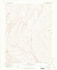
1964 Map of Razorback Ridge
USGS Topo · Published 1968About this map
Atencio Cabin stands as a solitary human marker in this mid-century survey of the high country straddling the Rio Blanco and Garfield County line. The landscape is defined by the significant elevations of Brush Mountain and the deep drainage networks that carve into the Roan Plateau. A sophisticated hydrological system is visible, dominated by the branching reaches of Cathedral Creek and its tributaries, alongside more obscure water sources like The Lake and several unnamed springs.
Find a feature on this map
20 named features on this map. Tap any name to fly to it.
Don’t see what you’re looking for? This feature index may not catch every label — zoom into the map to look around manually.
Map Details
Editions of this 1964 Razorback Ridge Map
3 editions found
Other maps of this area

1929 · Highmore
USGS Topo · 1:62,500

1952 · Yankee Gulch
USGS Topo · 1:24,000

1956 · Grand Junction
USGS Topo · 1:250,000

1959 · Grand Junction
USGS Topo · 1:250,000

1960 · Grand Junction
USGS Topo · 1:250,000

1962 · Grand Junction
USGS Topo · 1:250,000

1964 · Grand Junction
USGS Topo · 1:250,000

1964 · Brushy Point
USGS Topo · 1:24,000

1964 · Henderson Ridge
USGS Topo · 1:24,000

1964 · Black Cabin Gulch
USGS Topo · 1:24,000