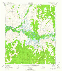
1950 Map of Candle A-5
USGS Topo · Published 1963About this map
Koyuk River meanders through this landscape, defining a network of drainages and remote mining outposts in mid-century Alaska. The settlement of Haycock serves as a focal point for activity, supported by a nearby Gold Mine and a Landing Strip essential for bush pilots in this roadless interior. A complex system of Tractor Trail routes connects these sites across the muskeg and uplands, linking Dime Landing on the riverbank to inland prospects. These trails follow several significant tributaries, including Stephensons Stream, Eldorado Creek, and Greenstone Creek. The presence of scattered Cabins and isolated Cabin sites suggests a seasonal or operational pattern of movement tied to the gold-bearing gravels of Dime Creek and Dollar Creek. To the south, drainages such as Kenwood Creek, Alameda Creek, and Willow Creek mark the transition into more mountainous terrain, showing how early 20th-century resource extraction relied on river access and tracked transport.
Find a feature on this map
16 named features on this map. Tap any name to fly to it.
Don’t see what you’re looking for? This feature index may not catch every label — zoom into the map to look around manually.
Map Details
Editions of this 1950 Candle A-5 Map
3 editions found
Other maps of this area

1948 · Norton Bay
USGS Topo · 1:250,000

1950 · Norton Bay D-6
USGS Topo · 1:63,360

1950 · Norton Bay D-5
USGS Topo · 1:63,360

1950 · Candle A-6
USGS Topo · 1:63,360

1950 · Candle B-5
USGS Topo · 1:63,360

1950 · Candle A-5
USGS Topo · 1:63,360

1950 · Candle B-6
USGS Topo · 1:63,360

1950 · Norton Bay D-4
USGS Topo · 1:63,360

1951 · Candle
USGS Topo · 1:250,000

1951 · Norton Bay
USGS Topo · 1:250,000