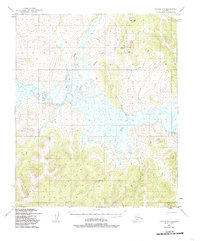
1950 Map of Candle A-5
USGS Topo · Published 1985About this map
Haycock and the surrounding wilderness of the Seward Peninsula are defined by the network of water and seasonal transport routes visible in this 1950 survey. The settlement at Haycock sits near a noted Gold Mine, illustrating the persistent mineral interests that shaped interior Alaska during this era. Movement through the territory relied on the Winter Trail and a Landing Strip near Dime Landing, reflecting a landscape where aviation and seasonal sled routes were more practical than permanent roads. The intricate drainage of the Koyuk River and its tributaries, including Peace River and Dime Creek, dominate the topography, interspersed with benchmark locations like Rabbit VABM 890. Remote Cabins scattered along these waterways suggest the isolated, subsistence-based lifestyle of the mid-century period.
Find a feature on this map
20 named features on this map. Tap any name to fly to it.
Don’t see what you’re looking for? This feature index may not catch every label — zoom into the map to look around manually.
Map Details
Editions of this 1950 Candle A-5 Map
3 editions found
Other maps of this area

1948 · Norton Bay
USGS Topo · 1:250,000

1950 · Norton Bay D-6
USGS Topo · 1:63,360

1950 · Norton Bay D-5
USGS Topo · 1:63,360

1950 · Candle A-6
USGS Topo · 1:63,360

1950 · Candle B-5
USGS Topo · 1:63,360

1950 · Candle A-5
USGS Topo · 1:63,360

1950 · Candle B-6
USGS Topo · 1:63,360

1950 · Norton Bay D-4
USGS Topo · 1:63,360

1951 · Candle
USGS Topo · 1:250,000

1951 · Norton Bay
USGS Topo · 1:250,000