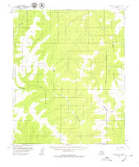
1954 Map of Candle B-2
USGS Topo · Published 1979About this map
The Continental Divide serves as the central geographic anchor for this mid-century survey of the Seward Peninsula interior. This ridge line dictates the flow of drainage across the territory, separating the headwaters of several remote watercourses. To the east, the South Fork Buckland River meanders through the lower elevations, while the southern and western portions of the sheet are defined by the winding paths of Kilusuk Creek and Kilusiktok Creek. The landscape is further structured by the east-west orientation of the Base Line, a fundamental surveying boundary that provides a rare human-imposed geometry to this undeveloped subarctic wilderness. This 1954 data, later published as part of the 1:63,360 scale series, documents a landscape void of roads or permanent settlements, preserving the state of the terrain as it existed before contemporary changes.
Find a feature on this map
5 named features on this map. Tap any name to fly to it.
Don’t see what you’re looking for? This feature index may not catch every label — zoom into the map to look around manually.
Map Details
Editions of this 1954 Candle B-2 Map
2 editions found
Other maps of this area

1951 · Candle
USGS Topo · 1:250,000

1954 · Candle A-2
USGS Topo · 1:63,360

1954 · Candle A-1
USGS Topo · 1:63,360

1954 · Candle C-2
USGS Topo · 1:63,360

1954 · Candle B-2
USGS Topo · 1:63,360

1954 · Candle C-1
USGS Topo · 1:63,360

1954 · Candle B-1
USGS Topo · 1:63,360

1955 · Candle
USGS Topo · 1:250,000

1955 · Candle B-3
USGS Topo · 1:63,360

1955 · Candle A-2
USGS Topo · 1:63,360