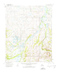
1955 Map of Candle C-4
USGS Topo · Published 1974About this map
The Buckland River and its major tributary, the West Fork Buckland River, dominate this mid-century topographic record of the Alaskan interior. The map captures a landscape defined by seasonal movement and traditional land use, notably marked by a Reindeer Corral on the eastern bank of the West Fork. Small Cabins are scattered near the riverbanks, representing the essential shelters used by hunters and herders in this area of the Seward Peninsula. The drainage network is complex, including Masutakatalik Creek and Goose Creek, providing a detailed look at the hydrology before major modern alterations. Mapping by the Army Map Service in 1955 emphasizes the natural topography, using 50-foot contours to delineate the ridges and valleys surrounding the river system.
Find a feature on this map
9 named features on this map. Tap any name to fly to it.
Don’t see what you’re looking for? This feature index may not catch every label — zoom into the map to look around manually.
Map Details
Editions of this 1955 Candle C-4 Map
2 editions found
Other maps of this area

1950 · Candle C-5
USGS Topo · 1:63,360

1950 · Candle B-5
USGS Topo · 1:63,360

1951 · Candle
USGS Topo · 1:250,000

1951 · Candle D-5
USGS Topo · 1:63,360

1955 · Candle
USGS Topo · 1:250,000

1955 · Candle B-3
USGS Topo · 1:63,360

1955 · Candle D-4
USGS Topo · 1:63,360

1955 · Candle C-4
USGS Topo · 1:63,360

1955 · Candle C-3
USGS Topo · 1:63,360
1955 · Candle D-3
USGS Topo · 1:63,360