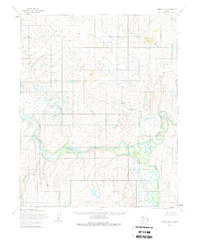
1955 Map of Candle D-4
USGS Topo · Published 1979About this map
The Buckland River meanders through this portion of the Alaska wilderness, where the waterway's complex oxbows and shifting channels dominate the southern landscape. Surveyed in the mid-1950s by the Army Map Service, the terrain is defined by a dense network of drainage systems feeding the main river, including the A-la-ka-yak River and the West Fork. These watercourses served as the primary natural corridors for movement through a region otherwise devoid of roads or permanent settlements at the time of the survey.
Find a feature on this map
8 named features on this map. Tap any name to fly to it.
Don’t see what you’re looking for? This feature index may not catch every label — zoom into the map to look around manually.
Map Details
Editions of this 1955 Candle D-4 Map
2 editions found
Other maps of this area

1950 · Candle C-5
USGS Topo · 1:63,360

1951 · Candle
USGS Topo · 1:250,000

1951 · Selawik
USGS Topo · 1:250,000

1951 · Candle D-5
USGS Topo · 1:63,360

1951 · Selawik A-5
USGS Topo · 1:63,360

1955 · Candle
USGS Topo · 1:250,000

1955 · Selawik A-4
USGS Topo · 1:63,360

1955 · Candle D-4
USGS Topo · 1:63,360

1955 · Candle C-4
USGS Topo · 1:63,360

1955 · Candle C-3
USGS Topo · 1:63,360