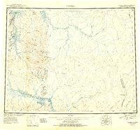
1951 Map of Candle
USGS Topo · Published 1951About this map
Candle serves as the primary hub of this landscape, situated near the head of Spafarief Bay where the Kiwalik River meets the sea. The geography of the early 1950s is defined by a dense network of mining-related infrastructure, most notably the Candle Ditch which contours along the western hillsides. Small settlements and outposts like Snyder Roadhouse, Haycock, and Dime Landing are connected by a system of trails and primitive airfields, including the Mining Camp Airstrip near Split Creek.
Find a feature on this map
80 named features on this map. Tap any name to fly to it.
Don’t see what you’re looking for? This feature index may not catch every label — zoom into the map to look around manually.
Map Details
Editions of this 1951 Candle Map
3 editions found

Other maps of this area

1945 · Nulato
USGS Topo · 1:250,000

1948 · Norton Bay
USGS Topo · 1:250,000

1950 · Kotzebue A-1
USGS Topo · 1:63,360

1950 · Bendeleben C-1
USGS Topo · 1:63,360

1950 · Bendeleben B-1
USGS Topo · 1:63,360

1950 · Bendeleben A-1
USGS Topo · 1:63,360

1950 · Norton Bay D-6
USGS Topo · 1:63,360

1950 · Bendeleben
USGS Topo · 1:250,000

1950 · Candle C-5
USGS Topo · 1:63,360

1950 · Norton Bay D-5
USGS Topo · 1:63,360