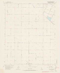
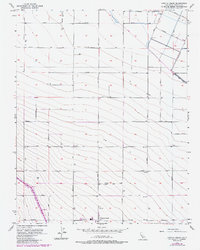
1956 Map of Cantua Creek
USGS Topo · Published 1966About this map
Cantua Creek serves as the focal point for this mid-1950s agricultural landscape in the San Joaquin Valley. The map reveals a highly structured grid of section lines and named avenues, such as Manning Ave and Mountain View Ave, which facilitate the region's intensive irrigation and farming operations. Water management is a central theme, evidenced by the prominent Beta Main Canal and numerous scattered wells and pumps across the Fresno County terrain. The survey captures an era of post-war agricultural expansion, where infrastructure like the local Landing Strip and the Water Tank near the settlement center supported the logistical needs of industrial-scale farming. Transportation routes like Oil City Ave and Calaveras Ave connect these productive tracts, illustrating the precise geometry of California's Central Valley development before later modernization changed the rural character.
Find a feature on this map
32 named features on this map. Tap any name to fly to it.
Don’t see what you’re looking for? This feature index may not catch every label — zoom into the map to look around manually.
Map Details
Editions of this 1956 Cantua Creek Map
5 editions found
Other maps of this area

1912 · Coalinga
USGS Topo · 1:125,000

1922 · Tufts Ranch
USGS Topo · 1:31,680

1923 · Levis
USGS Topo · 1:31,680

1923 · Englebrecht Ranch
USGS Topo · 1:31,680

1924 · Jamesan
USGS Topo · 1:31,680

1924 · Tranquillity
USGS Topo · 1:31,680

1925 · San Joaquin
USGS Topo · 1:31,680

1931 · Towne Oil Station
USGS Topo · 1:31,680

1931 · Mouth of Cantua Creek
USGS Topo · 1:31,680

1943 · Joaquin Rocks
USGS Topo · 1:62,500