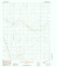
1984 Map of Canyon SE
USGS Topo · Published 1984About this map
Happy sits on the southern edge of this West Texas landscape, marking a point of transition between the high plains and the drainage systems that carve into the Llano Estacado. The topography is defined by the winding course of South Cita Creek, which snakes through the eastern half of the map, and the seasonal drainage of Happy Draw to the south. This 1984 provisional edition highlights the industrial infrastructure of Randall County, notably the Pipeline, Trans Line, and an Aqueduct that traverse the region. These features, alongside numerous surveyed elevation points, illustrate the mid-century management of water and energy resources across this portion of the Panhandle before more modern developments altered the surface landscape.
Find a feature on this map
6 named features on this map. Tap any name to fly to it.
Don’t see what you’re looking for? This feature index may not catch every label — zoom into the map to look around manually.
Map Details
Editions of this 1984 Canyon SE Map
2 editions found
Other maps of this area

1954 · Plainview
USGS Topo · 1:250,000

1956 · Fortress Cliff
USGS Topo · 1:24,000

1958 · Plainview
USGS Topo · 1:250,000

1960 · Canyon
USGS Topo · 1:62,500

1960 · Wayside
USGS Topo · 1:62,500

1965 · Happy
USGS Topo · 1:24,000

1966 · Tulia NW
USGS Topo · 1:24,000

1969 · Tule Lake NW
USGS Topo · 1:24,000
1984 · Canyon
USGS Topo · 1:24,000
1984 · Ogg
USGS Topo · 1:24,000