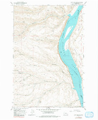
1966 Map of Cape Horn SE
USGS Topo · Published 1991About this map
Wanapum Lake dominates this mid-1960s landscape, representing a controlled stretch of the Columbia River at a normal pool elevation of 570 feet. The terrain is defined by dramatic vertical relief, where high plateaus like Perkins Bench and Babcock Bench overlook the deep incision of the river valley. The western shore is dissected by numerous drainages, including Quilomene Creek, Skookumchuck Creek, and Whiskey Dick Creek, which flow through steep features like Box Canyon. A historical Army Road and various 4WD tracks provide the primary access through this sparsely settled region. Evidence of local industry and geology appears in the form of a Borrow Pit and a Silica deposit on the eastern bank. The southern portion of the sheet includes a part of Ginkgo Petrified Forest State Park, while Scammon Landing marks a rare point of activity along the water's edge.
Find a feature on this map
30 named features on this map. Tap any name to fly to it.
Don’t see what you’re looking for? This feature index may not catch every label — zoom into the map to look around manually.
Map Details
Editions of this 1966 Cape Horn SE Map
Other maps of this area

1909 · Quincy
USGS Topo · 1:62,500

1910 · Quincy
USGS Topo · 1:62,500

1912 · Beverly
USGS Topo · 1:62,500

1920 · Colockum Pass
USGS Topo · 1:125,000

1922 · Colockum Pass
USGS Topo · 1:125,000

1939 · Boylston
USGS Topo · 1:48,000

1943 · Boylston
USGS Topo · 1:62,500

1950 · Yakima
USGS Topo · 1:250,000

1953 · Ginkgo
USGS Topo · 1:24,000
1953 · Boylston
USGS Topo · 1:24,000