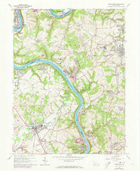
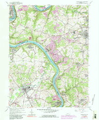
1964 Map of Carmichaels
USGS Topo · Published 1973About this map
The Monongahela River carves a deep, winding path through this region of Greene, Fayette, and Washington counties, dictating the placement of industrial hubs and transportation lines. Following the 1963 field check and 1973 photogrammetric revisions, the landscape reveals a dense network of mining and maritime activity, centered around landmarks like the Maxwell Lock and numerous mine dumps. Communities such as Crucible and Isabella line the riverbanks, while the interior is dotted with local institutions including the Carmichaels Area High Sch and several cemeteries. The presence of the Monongahela Railway and Penn Central tracks underscores the importance of the river corridor for moving coal and materials. Cultural sites like the Drive-in Theater near Carmichaels and the State Game Lands No 238 reflect the mid-century social fabric of these coal-country townships.
Find a feature on this map
84 named features on this map. Tap any name to fly to it.
Don’t see what you’re looking for? This feature index may not catch every label — zoom into the map to look around manually.
Map Details
Editions of this 1964 Carmichaels Map
5 editions found
Other maps of this area

1900 · Masontown
USGS Topo · 1:62,500

1901 · Amity
USGS Topo · 1:62,500

1901 · Waynesburg
USGS Topo · 1:62,500

1902 · Brownsville
USGS Topo · 1:62,500

1903 · Masontown
USGS Topo · 1:62,500

1904 · Amity
USGS Topo · 1:62,500

1904 · Waynesburg
USGS Topo · 1:62,500

1906 · Brownsville
USGS Topo · 1:62,500

1931 · Brownsville
USGS Topo · 1:62,500

1931 · Masontown
USGS Topo · 1:62,500