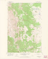
1958 Map of Cave Mountain
USGS Topo · Published 1967About this map
Lewis And Clark National Forest dominates this mid-century landscape along the eastern front of the Rockies, where the mountains meet the high plains. The topography is defined by prominent peaks like Cave Mountain and the towering Choteau Mountain, which separate the rugged interior from the ranching operations below. Evidence of early settlement and land use is visible in the presence of the Burfening Ranch and Lazy P Ranch, while a single Oil Well near Muddy Creek points to the area's natural resource potential. One of the most significant historical markers on the sheet is the Indian Burial Ground located east of Rinker Creek, providing a direct link to the Indigenous history of this terrain. The drainage patterns of the North Fork Teton River and South Fork Teton River provide a glimpse into the watershed that sustained these high-country ranches and the cattle industry during the late 1950s.
Find a feature on this map
27 named features on this map. Tap any name to fly to it.
Don’t see what you’re looking for? This feature index may not catch every label — zoom into the map to look around manually.
Map Details
Editions of this 1958 Cave Mountain Map
3 editions found
Other maps of this area

1903 · Saypo
USGS Topo · 1:125,000

1914 · Heart Butte
USGS Topo · 1:125,000

1918 · Heart Butte
USGS Topo · 1:125,000

1955 · Choteau
USGS Topo · 1:250,000

1957 · Choteau
USGS Topo · 1:250,000

1958 · Choteau
USGS Topo · 1:250,000

1958 · Ear Mountain
USGS Topo · 1:24,000

1958 · Lake Theboe
USGS Topo · 1:24,000

1958 · Cave Mountain
USGS Topo · 1:24,000

1958 · Mount Wright
USGS Topo · 1:24,000