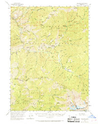
1955 Map of Cecilville
USGS Topo · Published 1959About this map
The South Fork Salmon River carves through the heart of this mid-century survey, a landscape defined by the legacies of the California gold rush. Cecilville stands as the primary hub, surrounded by active and historical extraction sites such as the King Solomon Mine and the White Bear Mine. The map documents the slow transition from intensive mining to a forest-management and ranching economy, indicated by the Crawford Cr Guard Sta and several family-named holdings like Georges Ranch and Blue Ridge Ranch. High-altitude landmarks such as Lafayette Point and the Salmon Mountains frame a network of isolated camps and cabins, including Jorstad Cabin and Five Dollar Camp. Of particular note for genealogists are the recorded sites of Summerville and Yoakumville, representing the fading footprints of once-essential canyon settlements.
Find a feature on this map
120 named features on this map. Tap any name to fly to it.
Don’t see what you’re looking for? This feature index may not catch every label — zoom into the map to look around manually.
Map Details
Editions of this 1955 Cecilville Map
5 editions found

Other maps of this area

1886 · Shasta
USGS Topo · 1:250,000

1890 · Red Bluff
USGS Topo · 1:250,000

1894 · Red Bluff
USGS Topo · 1:250,000

1894 · Shasta
USGS Topo · 1:250,000

1909 · Big Bar
USGS Topo · 1:96,000

1913 · Weaverville
USGS Topo · 1:125,000

1915 · Big Bar and Vicinity
USGS Topo · 1:250,000

1923 · Sawyers Bar
USGS Topo · 1:125,000

1931 · Etna
USGS Topo · 1:96,000

1934 · Etna
USGS Topo · 1:125,000