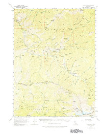
1955 Map of Cecilville
USGS Topo · Published 1974About this map
The Salmon River and its south fork carve through the high terrain of the Klamath National Forest, where the settlement of Cecilville serves as a remote hub for 1950s mining and ranching. The landscape is a complex network of gulches and ridges, punctuated by gold-era relics such as the King Solomon Mine, White Bear Mine, and Starveout Mine. This mid-century survey documents a wilderness being navigated by Jeep Trails and forest service infrastructure, including the Crawford Cr Guard Sta and Cecil Point Lookout. Genealogists will note the location of Schoolhouse Flat and family-named operations like Blue Ridge Ranch and Georges Ranch. The map also preserves the locations of earlier habitations that had transitioned to archaeological interest by the 1950s, such as Summerville (Site) and Yoakumville (Site) on the western edge near Graham (Site).
Find a feature on this map
120 named features on this map. Tap any name to fly to it.
Don’t see what you’re looking for? This feature index may not catch every label — zoom into the map to look around manually.
Map Details
Editions of this 1955 Cecilville Map
5 editions found

Other maps of this area

1886 · Shasta
USGS Topo · 1:250,000

1890 · Red Bluff
USGS Topo · 1:250,000

1894 · Red Bluff
USGS Topo · 1:250,000

1894 · Shasta
USGS Topo · 1:250,000

1909 · Big Bar
USGS Topo · 1:96,000

1913 · Weaverville
USGS Topo · 1:125,000

1915 · Big Bar and Vicinity
USGS Topo · 1:250,000

1923 · Sawyers Bar
USGS Topo · 1:125,000

1931 · Etna
USGS Topo · 1:96,000

1934 · Etna
USGS Topo · 1:125,000