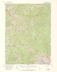
1955 Map of Cecilville
USGS Topo · Published 1969About this map
The Salmon River and its multiple forks carve through the high elevations of the Salmon Mountains and Trinity Alps in this mid-century survey. Gold mining legacy is evident across the terrain, with claims like the King Solomon Mine, Starvout Mine, and White Bear Mine dotting the drainages. The settlement of Cecilville serves as a central point along the river, while other sites like Summerville and Yoakumville reflect the shifting fortunes of these remote mountain outposts. The map reveals a network of high-country camps such as Five Dollar Camp and McDowell Camp, alongside essential fire lookouts at Cecil Point Lookout. Cattle ranching and early forest management are documented through labels for Blue Ridge Ranch, Schoolhouse Flat, and the Crawford Cr Guard Sta, capturing a landscape where resource extraction and backcountry habitation defined the local economy.
Find a feature on this map
127 named features on this map. Tap any name to fly to it.
Don’t see what you’re looking for? This feature index may not catch every label — zoom into the map to look around manually.
Map Details
Editions of this 1955 Cecilville Map
5 editions found

Other maps of this area

1886 · Shasta
USGS Topo · 1:250,000

1890 · Red Bluff
USGS Topo · 1:250,000

1894 · Red Bluff
USGS Topo · 1:250,000

1894 · Shasta
USGS Topo · 1:250,000

1909 · Big Bar
USGS Topo · 1:96,000

1913 · Weaverville
USGS Topo · 1:125,000

1915 · Big Bar and Vicinity
USGS Topo · 1:250,000

1923 · Sawyers Bar
USGS Topo · 1:125,000

1931 · Etna
USGS Topo · 1:96,000

1934 · Etna
USGS Topo · 1:125,000