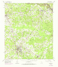
1958 Map of Center
USGS Topo · Published 1975About this map
The county seat of Center anchors this East Texas landscape, showing a mid-century hub where the Atchison Topeka and Santa Fe railway intersects a network of local roads leading to timber and agricultural communities. To the east, the Sabine River defines the border between Texas and Louisiana, with the rising waters of the Toledo Bend Reservoir beginning to alter the bottomlands near Logansport and Haslam. This era captures a transition in the local economy, where traditional landmarks like the Sawmill near Paxton and numerous gas wells operate alongside established rural institutions.
Find a feature on this map
85 named features on this map. Tap any name to fly to it.
Don’t see what you’re looking for? This feature index may not catch every label — zoom into the map to look around manually.
Map Details
Editions of this 1958 Center Map

Other maps of this area

1944 · Logansport
USGS Topo · 1:62,500

1944 · Patroon
USGS Topo · 1:62,500

1945 · Grand Cane
USGS Topo · 1:62,500

1945 · Socagee Bayou
USGS Topo · 1:62,500

1953 · Alexandria
USGS Topo · 1:250,000

1953 · Palestine
USGS Topo · 1:250,000

1955 · Shreveport
USGS Topo · 1:250,000

1955 · Alexandria
USGS Topo · 1:250,000

1956 · Shreveport
USGS Topo · 1:250,000

1956 · Tyler
USGS Topo · 1:250,000