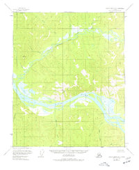
1956 Map of Charley River B-3
USGS Topo · Published 1977About this map
Yukon River waters dominate the southern portion of this mid-century survey, cutting a wide path through the eastern interior of Alaska. The confluence of the Kandik River and the Yukon River serves as a primary geographic anchor, showing the drainage patterns of several smaller tributaries like Sevenmile Creek and Mardow Creek. Rising above the riverbanks, the prominent Kathul Mountain provides a significant landmark in an otherwise unpopulated wilderness area. This 1950s documentation reflects the land before modern development, noting swampy lowlands and intricate island formations within the river channels. The terrain is marked by numerous named waterways including Washington Creek, Glenn Creek, and Logan Creek, which reflect the local naming conventions used by early surveyors and prospectors in the region.
Find a feature on this map
16 named features on this map. Tap any name to fly to it.
Don’t see what you’re looking for? This feature index may not catch every label — zoom into the map to look around manually.
Map Details
Editions of this 1956 Charley River B-3 Map
2 editions found
Other maps of this area

1951 · Charley River
USGS Topo · 1:250,000

1956 · Charley River C-2
USGS Topo · 1:63,360

1956 · Charley River A-4
USGS Topo · 1:63,360

1956 · Charley River B-3
USGS Topo · 1:63,360

1956 · Charley River B-2
USGS Topo · 1:63,360

1956 · Charley River C-4
USGS Topo · 1:63,360

1956 · Charley River A-3
USGS Topo · 1:63,360

1956 · Charley River A-2
USGS Topo · 1:63,360
1956 · Charley River C-3
USGS Topo · 1:63,360

1956 · Charley River B-4
USGS Topo · 1:63,360