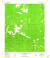
1956 Map of Charley River C-3
USGS Topo · Published 1960About this map
Black River meanders through the eastern edge of this Alaskan landscape, defining a region where permafrost-driven terrain features dominate the lowlands. The presence of numerous Pingos and isolated Pingo formations illustrates the dynamic geological processes of the Yukon-Koyukuk area during the mid-1950s. While higher elevations are marked by survey points like VABM 3414 Two, the lower drainage basins are defined by a network of waterways including Judge Creek, Mardow Creek, and Seventymile Creek. This map, based on aerial photography from 1954–1955, records an interior wilderness largely untouched by permanent settlements or roads, where even Easy Moose Creek suggests the seasonal patterns of the local environment before more modern developments reached the region.
Find a feature on this map
8 named features on this map. Tap any name to fly to it.
Don’t see what you’re looking for? This feature index may not catch every label — zoom into the map to look around manually.
Map Details
Editions of this 1956 Charley River C-3 Map
2 editions found
Other maps of this area

1951 · Charley River
USGS Topo · 1:250,000
1956 · Charley River D-4
USGS Topo · 1:63,360

1956 · Charley River C-2
USGS Topo · 1:63,360

1956 · Charley River D-3
USGS Topo · 1:63,360

1956 · Charley River B-3
USGS Topo · 1:63,360

1956 · Charley River B-2
USGS Topo · 1:63,360

1956 · Charley River C-4
USGS Topo · 1:63,360

1956 · Charley River D-2
USGS Topo · 1:63,360

1956 · Charley River B-4
USGS Topo · 1:63,360

1956 · Charley River
USGS Topo · 1:250,000