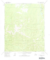
1956 Map of Charley River C-3
USGS Topo · Published 1984About this map
Black River dominates the eastern drainage of this interior Alaskan landscape, which was mapped from mid-1950s aerial photography. The terrain is defined by a dense network of high-elevation benchmarks and permafrost-related features, specifically several pingos scattered across the northern and eastern reaches. These ice-cored mounds provide distinct markers on an otherwise remote tundra landscape. To the southwest, Judge Creek and its tributaries, including Mardow Creek and Sevenmile Creek, carve through the upland country. The highest surveyed point, VABM 3414 Two, serves as a primary geodetic anchor for the area, illustrating the meticulous survey work conducted by the Geological Survey during the late 1950s to catalog the state’s interior wilderness.
Find a feature on this map
7 named features on this map. Tap any name to fly to it.
Don’t see what you’re looking for? This feature index may not catch every label — zoom into the map to look around manually.
Map Details
Editions of this 1956 Charley River C-3 Map
2 editions found
Other maps of this area

1951 · Charley River
USGS Topo · 1:250,000
1956 · Charley River D-4
USGS Topo · 1:63,360

1956 · Charley River C-2
USGS Topo · 1:63,360

1956 · Charley River D-3
USGS Topo · 1:63,360

1956 · Charley River B-3
USGS Topo · 1:63,360

1956 · Charley River B-2
USGS Topo · 1:63,360

1956 · Charley River C-4
USGS Topo · 1:63,360
1956 · Charley River C-3
USGS Topo · 1:63,360

1956 · Charley River D-2
USGS Topo · 1:63,360

1956 · Charley River B-4
USGS Topo · 1:63,360