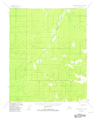
1956 Map of Charley River C-5
USGS Topo · Published 1981About this map
Little Black River meanders across this interior landscape, defining the hydrological character of the Charley River C-5 quadrangle during the mid-century era. Surveyed using photogrammetric methods from aerial photography taken in 1951 and 1954, the map documents a vast, roadless terrain dominated by complex wetland patterns and winding waterways. The intricate path of the Little Black River and its associated marshlands indicates a low-relief, slow-draining environment typical of this portion of the Alaskan interior before modern development. This document serves as a primary record of the natural topography and undisturbed drainage systems as they existed in the years following World War II, showing a landscape devoid of human settlements or industrial infrastructure at the time of the 1956 field annotation.
Find a feature on this map
1 named feature on this map. Tap any name to fly to it.
Don’t see what you’re looking for? This feature index may not catch every label — zoom into the map to look around manually.
Map Details
Editions of this 1956 Charley River C-5 Map
2 editions found
Other maps of this area

1951 · Charley River
USGS Topo · 1:250,000
1956 · Charley River D-4
USGS Topo · 1:63,360
1956 · Charley River D-5
USGS Topo · 1:63,360

1956 · Charley River C-5
USGS Topo · 1:63,360

1956 · Charley River C-6
USGS Topo · 1:63,360

1956 · Charley River B-6
USGS Topo · 1:63,360

1956 · Charley River B-5
USGS Topo · 1:63,360

1956 · Charley River C-4
USGS Topo · 1:63,360
1956 · Charley River D-6
USGS Topo · 1:63,360

1956 · Charley River B-4
USGS Topo · 1:63,360