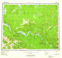
1956 Map of Charley River
USGS Topo · Published 1961About this map
The Yukon River carves a massive path through this interior Alaskan territory, serving as the primary corridor for remote life during the mid-1950s. This survey illustrates a landscape of isolation punctuated by critical river-side outposts like the Woodchopper Roadhouse and the small settlement of Nation at the confluence of the Yukon and Fourth of July Creek. Evidence of the region’s extractive history is visible through the Placer Mine near Woodchopper Creek, supported by the Woodchopper Airstrip for seasonal access.
Find a feature on this map
47 named features on this map. Tap any name to fly to it.
Don’t see what you’re looking for? This feature index may not catch every label — zoom into the map to look around manually.
Map Details
Editions of this 1956 Charley River Map
5 editions found

Other maps of this area

1899 · Fortymile
USGS Topo · 1:250,000

1950 · Big Delta
USGS Topo · 1:250,000

1951 · Big Delta
USGS Topo · 1:250,000

1951 · Fort Yukon
USGS Topo · 1:250,000

1951 · Charley River
USGS Topo · 1:250,000

1951 · Eagle
USGS Topo · 1:250,000

1951 · Black River
USGS Topo · 1:250,000

1951 · Circle
USGS Topo · 1:250,000

1955 · Circle A-1
USGS Topo · 1:63,360

1955 · Circle B-1
USGS Topo · 1:63,360