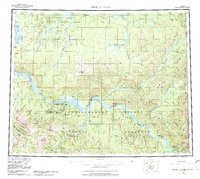
1956 Map of Charley River
USGS Topo · Published 1987About this map
Yukon River boatmen and interior explorers encountered a sparse but vital network of outposts along this stretch of the Alaska-Yukon border during the mid-20th century. The waterway serves as the primary artery through the Yukon-Charley Rivers National Preserve, connecting isolated sites like the Woodchopper Roadhouse and Slaven Cabin. These riverside landmarks, along with McGregor Cabin and Millers Camp, reflect the subsistence and mining history of the region. The landscape is defined by the confluence of major drainages including the Charley River and Kandik River, set against prominent heights such as Mount Ernest Patty and Kathul Mtn. To the north, the Yukon Flats National Wildlife Refuge marks a transition into the broad Yukon Flats, where numerous creeks like Paddle Creek and Black River meander toward the international boundary.
Find a feature on this map
78 named features on this map. Tap any name to fly to it.
Don’t see what you’re looking for? This feature index may not catch every label — zoom into the map to look around manually.
Map Details
Editions of this 1956 Charley River Map
5 editions found

Other maps of this area

1899 · Fortymile
USGS Topo · 1:250,000

1950 · Big Delta
USGS Topo · 1:250,000

1951 · Big Delta
USGS Topo · 1:250,000

1951 · Fort Yukon
USGS Topo · 1:250,000

1951 · Charley River
USGS Topo · 1:250,000

1951 · Eagle
USGS Topo · 1:250,000

1951 · Black River
USGS Topo · 1:250,000

1951 · Circle
USGS Topo · 1:250,000

1955 · Circle A-1
USGS Topo · 1:63,360

1955 · Circle B-1
USGS Topo · 1:63,360