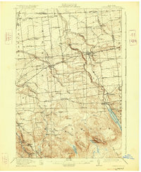
1915 Map of Chateaugay
USGS Topo · Published 1925About this map
Chateaugay serves as the primary hub of this 1915 survey, situated at the junction of the Rutland RR and the Chateaugay River. The landscape transitions from the agricultural plains along the Canada United States border to the high timber and industrial sites of the Adirondack foothills. Notable industrial features include Whites Kiln and Blairs Kiln, alongside water-powered sites like Cooks Mill and Boyce Mill. The map documents a dense network of early 20th-century rural infrastructure, including dozens of numbered schoolhouses and the isolated White Church. To the south, the topography rises sharply toward Figure Eight Mtn and East Mountain, while the resort and post office at Chateaugay Lake P.O. mark the northern tip of Lower Chateaugay Lake.
Find a feature on this map
88 named features on this map. Tap any name to fly to it.
Don’t see what you’re looking for? This feature index may not catch every label — zoom into the map to look around manually.
Map Details
Editions of this 1915 Chateaugay Map
4 editions found
Other maps of this area

1906 · Loon Lake
USGS Topo · 1:62,500

1908 · Loon Lake
USGS Topo · 1:62,500

1911 · Lyon Mountain
USGS Topo · 1:62,500

1913 · Lyon Mountain
USGS Topo · 1:62,500

1915 · Churubusco
USGS Topo · 1:62,500

1915 · Chateaugay
USGS Topo · 1:62,500

1915 · Malone
USGS Topo · 1:62,500

1917 · Malone
USGS Topo · 1:62,500

1921 · Santa Clara
USGS Topo · 1:62,500

1923 · Santa Clara
USGS Topo · 1:62,500