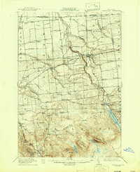
1915 Map of Chateaugay
USGS Topo · Published 1944About this map
Chateaugay serves as the industrial and transport hub of this Franklin County landscape, where the Rutland RR and Ogdensburg Div meet. The terrain transitions from the agricultural flats of North Burke and Coveytown Corners in the north toward the rising Adirondack foothills in the south. The hydro-power of the Chateaugay River is evident at Chateaugay Chasm, supporting local industry like Cooks Mill.
Find a feature on this map
83 named features on this map. Tap any name to fly to it.
Don’t see what you’re looking for? This feature index may not catch every label — zoom into the map to look around manually.
Map Details
Editions of this 1915 Chateaugay Map
4 editions found
Other maps of this area

1906 · Loon Lake
USGS Topo · 1:62,500

1908 · Loon Lake
USGS Topo · 1:62,500

1911 · Lyon Mountain
USGS Topo · 1:62,500

1913 · Lyon Mountain
USGS Topo · 1:62,500

1915 · Churubusco
USGS Topo · 1:62,500

1915 · Chateaugay
USGS Topo · 1:62,500

1915 · Malone
USGS Topo · 1:62,500

1917 · Malone
USGS Topo · 1:62,500

1921 · Santa Clara
USGS Topo · 1:62,500

1923 · Santa Clara
USGS Topo · 1:62,500