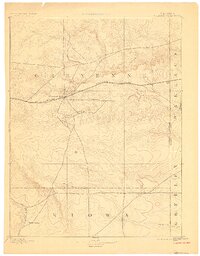
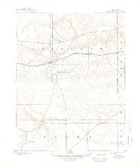
1894 Map of Cheyenne Wells
USGS Topo · Published 1900About this map
Cheyenne Wells serves as a central hub for this High Plains landscape, where the iron rails of the Union Pacific Railroad cut a straight path toward the Colorado Kansas border. Surveyed in 1890, the map illustrates a network of wagon roads radiating from the rail line to outlying points like Arapahoe and the southern settlement of Water Valley. The hydrology of the region is defined by ephemeral drainages including Smoky Creek, Ladder Creek, and the curiously named White Woman Creek. This 1890s topography reveals how early settlement patterns in Cheyenne and Kiowa counties were dictated by the dual necessities of railway access and the seasonal water courses that cross the shortgrass prairie.
Find a feature on this map
15 named features on this map. Tap any name to fly to it.
Don’t see what you’re looking for? This feature index may not catch every label — zoom into the map to look around manually.
Map Details
Editions of this 1894 Cheyenne Wells Map
6 editions found
Other maps of this area

1890 · Granada
USGS Topo · 1:125,000

1891 · Kit Carson
USGS Topo · 1:125,000

1892 · Lamar
USGS Topo · 1:125,000

1892 · Cheyenne Wells
USGS Topo · 1:125,000

1892 · Granada
USGS Topo · 1:125,000

1893 · Kit Carson
USGS Topo · 1:125,000

1894 · Cheyenne Wells
USGS Topo · 1:125,000

1894 · Granada
USGS Topo · 1:125,000

1954 · Limon
USGS Topo · 1:250,000

1954 · Lamar
USGS Topo · 1:250,000