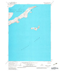
1963 Map of Chignik A-1
USGS Topo · Published 1983About this map
The Alaska Peninsula National Wildlife Refuge dominates this coastal landscape, protecting a complex shoreline where the land meets the Pacific Ocean. This survey captures the intricate geography of the Chignik area, characterized by deep inlets and prominent headlands such as Cape Castle and Tuliumnit Pt. The hydrographic data, compiled from mid-century charts, reveals the sheltered waters of Castle Bay and smaller indentations like Nikolai Cove and Necessity Cove. South of the mainland, the isolated Chankliut Island rises from the sea, marked by steep Cliffs. The topography was photogrammetrically mapped from 1962 aerial photography, providing a precise record of this undeveloped maritime environment during a period of expanding federal conservation efforts in Alaska.
Find a feature on this map
9 named features on this map. Tap any name to fly to it.
Don’t see what you’re looking for? This feature index may not catch every label — zoom into the map to look around manually.
Map Details
Editions of this 1963 Chignik A-1 Map
3 editions found
Other maps of this area

1951 · Stepovak Bay
USGS Topo · 1:250,000

1951 · Sutwik Island
USGS Topo · 1:250,000

1963 · Stepovak Bay D-2
USGS Topo · 1:63,360

1963 · Chignik B-2
USGS Topo · 1:63,360

1963 · Chignik B-1
USGS Topo · 1:63,360

1963 · Chignik A-2
USGS Topo · 1:63,360

1963 · Sutwik Island B-6
USGS Topo · 1:63,360
1963 · Chignik A-1
USGS Topo · 1:63,360

1963 · Sutwik Island
USGS Topo · 1:250,000

1963 · Chignik
USGS Topo · 1:250,000