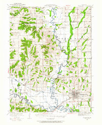
1921 Map of Chillicothe
USGS Topo · Published 1963About this map
Chillicothe serves as the focal point of this 1920s-era landscape, where the confluence of the Grand River and the Thompson River dictates the region's agricultural and transport layout. The map documents an extensive network of rural education, featuring dozens of localized institutions such as American Bottoms School, Happy Hollow School, and Black Hills School. This high density of one-room schoolhouses and country churches like Shelburn Church reflects the tight-knit settlement patterns of Livingston County before the consolidation of rural districts.
Find a feature on this map
75 named features on this map. Tap any name to fly to it.
Don’t see what you’re looking for? This feature index may not catch every label — zoom into the map to look around manually.
Map Details
Editions of this 1921 Chillicothe Map
2 editions found
Other maps of this area

1921 · Chillicothe
USGS Topo · 1:62,500

1922 · Gallatin
USGS Topo · 1:62,500

1923 · Chillicothe
USGS Topo · 1:62,500

1924 · Dawn
USGS Topo · 1:62,500

1924 · Braymer
USGS Topo · 1:62,500

1924 · Chula
USGS Topo · 1:62,500

1924 · Hale
USGS Topo · 1:62,500

1925 · Gilman
USGS Topo · 1:62,500

1946 · Gilman
USGS Topo · 1:48,000

1946 · Galt
USGS Topo · 1:62,500