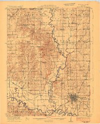
1923 Map of Chillicothe
USGS Topo · Published 1923About this map
The Grand River and Thompson River converge in this detailed early 1920s survey of Livingston and Grundy counties. Chillicothe serves as the dominant rail hub, situated at the intersection of several major lines including the Wabash, the Chicago Burlington and Quincy, and the Chicago Milwaukee and St Paul. The landscape is a dense network of early rural education, with dozens of family and neighborhood-named schools such as American Bottoms School, Happy Hollow School, and Blackburn School scattered across the townships of Jefferson, Jackson, and Cream Ridge. The intricate river meanders and the proximity of the Wabash railroad to the riverbanks highlight the era's reliance on both water and rail transport. Smaller settlements like Sampsell and Mooresville anchor the western reaches, providing a clear view of the agricultural and transit patterns of northern Missouri between the wars.
Find a feature on this map
75 named features on this map. Tap any name to fly to it.
Don’t see what you’re looking for? This feature index may not catch every label — zoom into the map to look around manually.
Map Details
Editions of this 1923 Chillicothe Map
2 editions found
Other maps of this area

1921 · Chillicothe
USGS Topo · 1:62,500

1922 · Gallatin
USGS Topo · 1:62,500

1923 · Chillicothe
USGS Topo · 1:62,500

1924 · Dawn
USGS Topo · 1:62,500

1924 · Braymer
USGS Topo · 1:62,500

1924 · Chula
USGS Topo · 1:62,500

1924 · Hale
USGS Topo · 1:62,500

1925 · Gilman
USGS Topo · 1:62,500

1946 · Gilman
USGS Topo · 1:48,000

1946 · Galt
USGS Topo · 1:62,500