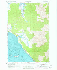
1949 Map of Chinook
USGS Topo · Published 1977About this map
The tidal landscape of the lower Columbia River estuary defines this 1949 survey, centered on the community of Chinook. The area is characterized by a series of family ranch holdings such as Kyle Ranch, Goulter Ranch, and Gile Ranch, which dot the lowlands between Bear River Ridge and the Baker Bay shoreline. To the south, Fort Columbia Historical State Park occupies the strategic heights of Scarboro Hill overlooking Chinook Point, a key navigational landmark for the Ilwaco Channel. Marine engineering is evident in the Sand Island Dike Light and the Chinook Jetty, which manage the shifting sands of Sand Island. This postwar map also records the local infrastructure of the era, from the Port of Ilwaco Airport to the cluster of homes at Stringtown.
Find a feature on this map
30 named features on this map. Tap any name to fly to it.
Don’t see what you’re looking for? This feature index may not catch every label — zoom into the map to look around manually.
Map Details
Editions of this 1949 Chinook Map
4 editions found
Other maps of this area

1919 · Astoria
USGS Topo · 1:62,500

1938 · Cape Disappointment
USGS Topo · 1:62,500

1938 · Fort Columbia
USGS Topo · 1:62,500

1939 · Astoria
USGS Topo · 1:62,500

1943 · Fort Columbia
USGS Topo · 1:62,500

1943 · Copalis Beach
USGS Topo · 1:250,000

1949 · Astoria
USGS Topo · 1:24,000

1949 · Chinook
USGS Topo · 1:24,000

1949 · Oman Ranch
USGS Topo · 1:24,000

1949 · Knappton
USGS Topo · 1:24,000