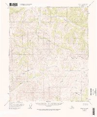
1955 Map of Circle A-1
USGS Topo · Published 1967About this map
Military Reservation lands dominate the southwestern portion of this Alaskan interior landscape, where the Salcha River meanders through high-elevation terrain. This mid-century survey captures a watershed transition point where the South Fork Birch Creek and Yukon Fork flow north, while the Salcha drainage moves south toward the Tanana Valley. The map documents the vast, uninhabited stretches of the Fairbanks North Star Borough boundary before significant modern development reached this part of the interior. Tributaries like Caribou Creek, Williams Creek, and Puzzle Gulch define the intricate drainage patterns of the upland ridges. Localized features such as Big Windy Creek and Cottonwood Cr provide essential landmarks for understanding the hydrology and land use of this remote subarctic region during the 1950s.
Find a feature on this map
13 named features on this map. Tap any name to fly to it.
Don’t see what you’re looking for? This feature index may not catch every label — zoom into the map to look around manually.
Map Details
Editions of this 1955 Circle A-1 Map
3 editions found
Other maps of this area

1950 · Big Delta
USGS Topo · 1:250,000

1951 · Big Delta
USGS Topo · 1:250,000

1951 · Charley River
USGS Topo · 1:250,000

1951 · Eagle
USGS Topo · 1:250,000

1951 · Circle
USGS Topo · 1:250,000

1955 · Circle A-2
USGS Topo · 1:63,360

1955 · Circle A-1
USGS Topo · 1:63,360

1955 · Circle B-1
USGS Topo · 1:63,360

1955 · Circle B-2
USGS Topo · 1:63,360

1955 · Circle
USGS Topo · 1:250,000