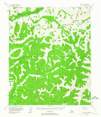
1954 Map of Circle A-6
USGS Topo · Published 1964About this map
The Steese Highway cuts through the northern reaches of this Alaskan interior landscape, following the course of the Chatanika River as it winds through the hills. This mid-century survey documents the critical infrastructure of the era, notably the Davidson Ditch, a massive hydraulic mining conduit that once carried water across the rugged terrain to support gold operations. The drainage patterns are meticulously detailed, showing the intricate network of the Little Chena River and its numerous tributaries such as Anaconda Creek and Caribou Creek. High points like Twin Buttes provide orientation in a wilderness marked by distinctive local names like First Pup, Second Pup, and Frozenfoot Cr. A lone Cabin near the river highlights the sparse but present human footprint in this remote region during the 1950s.
Find a feature on this map
29 named features on this map. Tap any name to fly to it.
Don’t see what you’re looking for? This feature index may not catch every label — zoom into the map to look around manually.
Map Details
Editions of this 1954 Circle A-6 Map
4 editions found

Other maps of this area

1945 · Livengood
USGS Topo · 1:250,000

1949 · Fairbanks D-1
USGS Topo · 1:62,500

1950 · Fairbanks
USGS Topo · 1:250,000

1950 · Big Delta
USGS Topo · 1:250,000

1950 · Big Delta D-6
USGS Topo · 1:63,360

1951 · Big Delta
USGS Topo · 1:250,000

1951 · Fairbanks
USGS Topo · 1:250,000

1951 · Livengood
USGS Topo · 1:250,000

1951 · Circle
USGS Topo · 1:250,000

1951 · Circle A-5
USGS Topo · 1:63,360