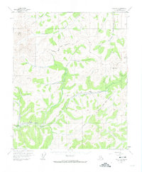
1954 Map of Circle B-5
USGS Topo · Published 1974About this map
The Chatanika River flows across this interior landscape within the Fairbanks North Star Borough, where a complex network of waterways supported early mining and transportation. The presence of a Ditch and Flume alongside the river, near a Placer Mine, reflects the hydraulic engineering required for mineral extraction in this demanding terrain. Prominent summits like Mount Prindle and VABM McManus 4184 anchor the topography, while the Steese Highway provides the primary corridor through the valley, passing by a Gaging Sta and a lone Cabin. Streams such as McManus Creek, Faith Creek, and Hope Creek carve through the uplands, tracing the routes once vital to local prospectors. This 1950s-era survey preserves the spatial relationship between these remote work sites and the natural drainages of Sourdough Creek and Crooked Creek during a period of ongoing interior development.
Find a feature on this map
35 named features on this map. Tap any name to fly to it.
Don’t see what you’re looking for? This feature index may not catch every label — zoom into the map to look around manually.
Map Details
Editions of this 1954 Circle B-5 Map
4 editions found

Other maps of this area

1951 · Circle
USGS Topo · 1:250,000

1951 · Circle A-5
USGS Topo · 1:63,360

1951 · Circle C-6
USGS Topo · 1:63,360

1952 · Circle A-4
USGS Topo · 1:63,360

1952 · Circle B-4
USGS Topo · 1:63,360

1952 · Circle C-4
USGS Topo · 1:63,360

1952 · Circle C-5
USGS Topo · 1:63,360

1952 · Circle A-5
USGS Topo · 1:63,360

1954 · Circle C-5
USGS Topo · 1:63,360

1954 · Circle A-6
USGS Topo · 1:63,360