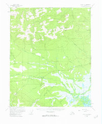
1955 Map of Circle C-2
USGS Topo · Published 1963About this map
The Central settlement serves as the primary hub of activity in this mid-century Alaskan interior landscape, situated where the Steese Highway cuts through a complex network of waterways. To the north, the Crazy Mountains and Boulder Hill dominate the topography, giving way to the expansive drainage basins of Albert Creek and Crooked Creek. The presence of a Landing Strip and a series of Placer mining sites illustrates the region's reliance on air transport and mineral extraction during the 1950s. A web of seasonal routes, including the Winter Trail and Louie Run, connects the high ground to the marshy lowlands surrounding Medicine Lake. The map reveals a landscape defined by the intersection of remote mining claims and the vital overland lifeline of the highway, with numerous family-named landmarks like Deadwood Creek and Ketchem Creek signaling the area's prospecting history.
Find a feature on this map
22 named features on this map. Tap any name to fly to it.
Don’t see what you’re looking for? This feature index may not catch every label — zoom into the map to look around manually.
Map Details
Editions of this 1955 Circle C-2 Map
3 editions found
Other maps of this area

1951 · Circle
USGS Topo · 1:250,000

1952 · Circle D-3
USGS Topo · 1:63,360

1952 · Circle D-2
USGS Topo · 1:63,360

1955 · Circle B-3
USGS Topo · 1:63,360

1955 · Circle C-3
USGS Topo · 1:63,360

1955 · Circle B-1
USGS Topo · 1:63,360

1955 · Circle C-2
USGS Topo · 1:63,360

1955 · Circle D-1
USGS Topo · 1:63,360

1955 · Circle B-2
USGS Topo · 1:63,360

1955 · Circle C-1
USGS Topo · 1:63,360