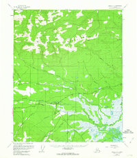
1955 Map of Circle C-2
USGS Topo · Published 1963About this map
Central serves as the primary hub for this interior Alaskan landscape, situated where the Steese Highway meets a complex network of waterways and trails. The settlement's regional importance is underscored by its proximity to a Landing Strip and a nearby Graveyard, features common to isolated outposts of the mid-20th century. To the north, the terrain rises into the Crazy Mountains, while the southern lowlands are defined by the winding paths of Crooked Creek and Albert Creek. Evidence of local infrastructure and resource extraction appears through scattered Gravel Pit locations and a Winter Trail leading toward the southeast corner near Medicine Lake and the small settlement of Medicine. This survey captures the transition from the high peaks of Boulder Hill to the marshy drainage basins that shaped the movement and habitation patterns of the Yukon-Koyukuk region.
Find a feature on this map
21 named features on this map. Tap any name to fly to it.
Don’t see what you’re looking for? This feature index may not catch every label — zoom into the map to look around manually.
Map Details
Editions of this 1955 Circle C-2 Map
3 editions found
Other maps of this area

1951 · Circle
USGS Topo · 1:250,000

1952 · Circle D-3
USGS Topo · 1:63,360

1952 · Circle D-2
USGS Topo · 1:63,360

1955 · Circle B-3
USGS Topo · 1:63,360

1955 · Circle C-3
USGS Topo · 1:63,360

1955 · Circle B-1
USGS Topo · 1:63,360

1955 · Circle C-2
USGS Topo · 1:63,360

1955 · Circle D-1
USGS Topo · 1:63,360

1955 · Circle B-2
USGS Topo · 1:63,360

1955 · Circle C-1
USGS Topo · 1:63,360