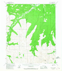
1952 Map of Circle C-4
USGS Topo · Published 1967About this map
Preacher Creek and its many tributaries carve through this interior Alaska landscape as it appeared during the early 1950s. The map captures a region defined by high elevations and drainage basins, notably featuring Porcupine Dome and Pinnell Mountain in the southern portion of the quadrangle. A solitary Placer Mine located along Porcupine Creek provides evidence of the enduring search for minerals in this part of the Yukon-Koyukuk region.
Find a feature on this map
11 named features on this map. Tap any name to fly to it.
Don’t see what you’re looking for? This feature index may not catch every label — zoom into the map to look around manually.
Map Details
Editions of this 1952 Circle C-4 Map
3 editions found
Other maps of this area

1951 · Circle
USGS Topo · 1:250,000

1952 · Circle D-4
USGS Topo · 1:63,360

1952 · Circle D-3
USGS Topo · 1:63,360

1952 · Circle B-4
USGS Topo · 1:63,360

1952 · Circle C-4
USGS Topo · 1:63,360

1952 · Circle D-5
USGS Topo · 1:63,360

1952 · Circle C-5
USGS Topo · 1:63,360

1954 · Circle C-5
USGS Topo · 1:63,360

1954 · Circle D-5
USGS Topo · 1:63,360

1954 · Circle B-5
USGS Topo · 1:63,360