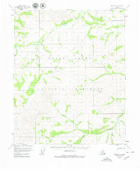
1952 Map of Circle C-5
USGS Topo · Published 1980About this map
Yukon Flats National Monument defines this Alaskan interior landscape, centered on a complex network of waterways as they appeared during the early 1950s. The topographic detail follows the winding course of Preacher Creek and its many tributaries, including the North Fork and the Costa Fork. The map provides a look at the hydrologic patterns of the Yukon Flats region before later land-use designations, capturing a wilderness area defined by drainage basins like those of American Creek and Bachelor Creek. Small-scale features such as Quartz Creek and Convert Creek underscore the intricate riparian environment south of the mountain peak labeled McKinley, located near the headwaters of McKinley Creek. This survey reflects the remote character of the territory during a period when unsurveyed land lines were predetermined by the Bureau of Land Management.
Find a feature on this map
11 named features on this map. Tap any name to fly to it.
Don’t see what you’re looking for? This feature index may not catch every label — zoom into the map to look around manually.
Map Details
Editions of this 1952 Circle C-5 Map
2 editions found
Other maps of this area

1951 · Circle
USGS Topo · 1:250,000

1951 · Circle D-6
USGS Topo · 1:63,360

1951 · Circle C-6
USGS Topo · 1:63,360

1952 · Circle D-4
USGS Topo · 1:63,360

1952 · Circle B-4
USGS Topo · 1:63,360

1952 · Circle C-4
USGS Topo · 1:63,360

1952 · Circle D-5
USGS Topo · 1:63,360

1952 · Circle C-5
USGS Topo · 1:63,360

1954 · Circle C-5
USGS Topo · 1:63,360

1954 · Circle B-6
USGS Topo · 1:63,360