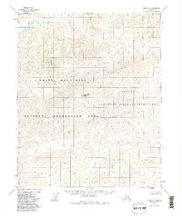
1951 Map of Circle C-6
USGS Topo · Published 1986About this map
The White Mountains dominate this 1951 photogrammetric study, reflecting a remote subarctic landscape before the formalization of major federal protections. The area is defined by a dense network of drainages, where Beaver Creek and its tributaries, such as Mascot Creek and Yellow Creek, carve through the high terrain. While the topography was captured in the early 1950s, the map's later revision includes boundaries for the Steese National Conservation Area and the White Mountains National Recreation Area, established by the Alaska National Interest Lands Conservation Act. Rising significantly above the surrounding creeks, Rocky Mountain serves as a central landmark in this wilderness. The map captures an era of unsurveyed land lines under the Fairbanks Seward Meridian, where only the wettest swamps and primary watercourses like Quartz Creek and Bear Creek break the complex contour intervals.
Find a feature on this map
12 named features on this map. Tap any name to fly to it.
Don’t see what you’re looking for? This feature index may not catch every label — zoom into the map to look around manually.
Map Details
Editions of this 1951 Circle C-6 Map
3 editions found
Other maps of this area

1945 · Livengood
USGS Topo · 1:250,000

1951 · Livengood
USGS Topo · 1:250,000

1951 · Circle
USGS Topo · 1:250,000

1951 · Circle D-6
USGS Topo · 1:63,360

1951 · Livengood C-1
USGS Topo · 1:63,360

1951 · Circle C-6
USGS Topo · 1:63,360

1952 · Livengood D-1
USGS Topo · 1:63,360

1952 · Circle D-5
USGS Topo · 1:63,360

1952 · Circle C-5
USGS Topo · 1:63,360

1954 · Circle C-5
USGS Topo · 1:63,360