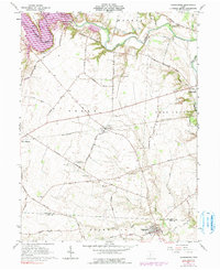
1961 Map of Clarksburg
USGS Topo · Published 1990About this map
Deer Creek meanders through this agricultural landscape, forming the boundary between Monroe, Perry, and Deer Creek townships. The map is a significant record for family historians, documenting numerous small family burial grounds such as the Anton Kellar Farm Cem, Arthur Dunlap Farm Cem, and Grant Campbell Farm Cem. These cemeteries are often the only remaining markers of the 19th-century families who established the farmsteads along the winding Williamsport Crownover Mill Road.
Find a feature on this map
54 named features on this map. Tap any name to fly to it.
Don’t see what you’re looking for? This feature index may not catch every label — zoom into the map to look around manually.
Map Details
Editions of this 1961 Clarksburg Map
3 editions found
Other maps of this area

1906 · Mt Sterling
USGS Topo · 1:62,500

1911 · Era
USGS Topo · 1:62,500

1912 · Roxabell
USGS Topo · 1:62,500

1913 · Era
USGS Topo · 1:62,500

1914 · Roxabell
USGS Topo · 1:62,500

1917 · Greenfield
USGS Topo · 1:62,500

1943 · Era
USGS Topo · 1:62,500

1944 · Greenfield
USGS Topo · 1:62,500

1944 · Roxabell
USGS Topo · 1:62,500

1947 · Columbus
USGS Topo · 1:250,000