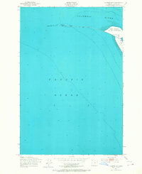
1951 Map of Clatsop Spit
USGS Topo · Published 1968About this map
Fort Stevens Military Reservation anchors the landward portion of this coastal survey, where the Columbia River meets the Pacific Ocean. The geography is defined by the shifting sands of Clatsop Spit and the engineered maritime defenses required to keep the river mouth navigable. Nautical features include the South Jetty and several instances of a Submerged Breakwater, as well as a Tank and Piling fields. The map records a specific moment in maritime safety and defense, noting a Lookout Tower and a road leading to a Bridge Unsafe crossing over the Tidal Flat. This intersection of the Oregon coastline and the great river demonstrates the precarious nature of coastal infrastructure in the mid-20th century.
Find a feature on this map
11 named features on this map. Tap any name to fly to it.
Don’t see what you’re looking for? This feature index may not catch every label — zoom into the map to look around manually.
Map Details
Editions of this 1951 Clatsop Spit Map
3 editions found
Other maps of this area

1919 · Astoria
USGS Topo · 1:62,500

1938 · Cape Disappointment
USGS Topo · 1:62,500

1938 · Fort Columbia
USGS Topo · 1:62,500

1939 · Astoria
USGS Topo · 1:62,500

1943 · Fort Columbia
USGS Topo · 1:62,500

1943 · Copalis Beach
USGS Topo · 1:250,000

1949 · Chinook
USGS Topo · 1:24,000

1949 · Gearhart
USGS Topo · 1:24,000
1949 · Cape Disappointment
USGS Topo · 1:24,000

1951 · Copalis Beach
USGS Topo · 1:250,000