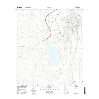
2016 Map of Cleburne West
USGS Topo · Published 2016About this map
Lake Pat Cleburne dominates the central landscape of this Johnson County region, serving as a primary hydrological focal point where the Nolan River and several of its tributaries converge. To the north, the growing urban grid of Cleburne expands toward the Cleburne Regional Airport, showing a dense network of residential streets and municipal development. The southern portion of the map transitions into more rural terrain near the community of Rio Vista, defined by the winding paths of Buffalo Creek and Haley Branch. Local water features like Cleburne Spring and Town Branch underscore the area's historical reliance on the Nolan River watershed. The map details a sophisticated transportation network, from the major thoroughfares of Overhill Drive to the smaller rural routes like County Road 1210, illustrating the balance between the established city center and the outlying agricultural and residential lands.
Find a feature on this map
172 named features on this map. Tap any name to fly to it.
Don’t see what you’re looking for? This feature index may not catch every label — zoom into the map to look around manually.
Map Details
Editions of this 2016 Cleburne West Map
This is the sole edition of this map. No revisions or reprints were ever made.
Other maps of this area

1889 · Granbury
USGS Topo · 1:125,000

1891 · Cleburne
USGS Topo · 1:125,000

1894 · Cleburne
USGS Topo · 1:125,000

1924 · Cleburne 3-B
USGS Topo · 1:48,000

1924 · Granbury 4-a
USGS Topo · 1:48,000

1927 · Blum
USGS Topo · 1:62,500

1928 · Godley
USGS Topo · 1:62,500

1931 · Morgan
USGS Topo · 1:62,500

1954 · Dallas
USGS Topo · 1:250,000

1958 · Dallas
USGS Topo · 1:250,000