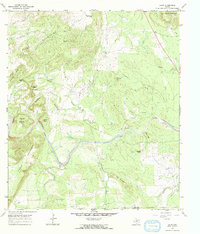
1967 Map of Click
USGS Topo · Published 1970About this map
The Click settlement sits at the center of this landscape in the late 1960s, marking a transition point between the Riley Mountains to the northwest and the winding course of Sandy Creek. This area of the Llano Uplift is defined by its complex geology, where names like Granite Knob and Quartz Knob suggest the mineral-rich character of the terrain. The map traces the confluence of numerous waterways, including Comanche Creek and Barnett Branch, which feed into the larger creek systems that have shaped the local ranching and settlement patterns. Local history is anchored by the Martin Cem in the southwest, while prominent landmarks like Packsaddle Mountain and Hickory Bluff provided essential orientation for early residents. The southern boundary of the map follows the jagged transition between Llano Co and Blanco Co, highlighting the rural isolation of the central Texas hill country during this era.
Find a feature on this map
29 named features on this map. Tap any name to fly to it.
Don’t see what you’re looking for? This feature index may not catch every label — zoom into the map to look around manually.
Map Details
Editions of this 1967 Click Map
This is the sole edition of this map. No revisions or reprints were ever made.
Other maps of this area

1887 · Llano
USGS Topo · 1:125,000

1887 · Blanco
USGS Topo · 1:125,000

1887 · Burnet
USGS Topo · 1:125,000

1893 · Burnet
USGS Topo · 1:125,000

1894 · Fredericksburg
USGS Topo · 1:125,000

1894 · Blanco
USGS Topo · 1:125,000

1894 · Llano
USGS Topo · 1:125,000

1903 · Burnet
USGS Topo · 1:125,000

1904 · Llano
USGS Topo · 1:125,000

1909 · Llano
USGS Topo · 1:125,000