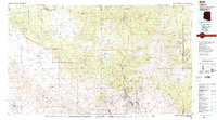
1986 Map of Clifton
USGS Topo · Published 1987About this map
The industrial complex at Morenci and the Morenci Open Pit dominate the eastern landscape of this 1986 survey, illustrating the massive scale of copper mining operations in Greenlee Co. This high-elevation terrain transitions from the Natanes Plateau and Nantac Rim into the deep canyons of the Apache National Forest. The map documents the tightly clustered settlements supporting the mine, including Clifton, Stargo, and Plantsite, alongside the vital Southern Pacific rail infrastructure.
Find a feature on this map
41 named features on this map. Tap any name to fly to it.
Don’t see what you’re looking for? This feature index may not catch every label — zoom into the map to look around manually.
Map Details
Editions of this 1986 Clifton Map
2 editions found
Other maps of this area

1902 · Clifton
USGS Topo · 1:62,500

1910 · Mogollon
USGS Topo · 1:125,000

1912 · Mogollon
USGS Topo · 1:125,000

1913 · Morenci
USGS Topo · 1:125,000

1915 · Morenci
USGS Topo · 1:125,000

1915 · Reserve
USGS Topo · 1:125,000

1918 · Reserve
USGS Topo · 1:125,000

1922 · Nutrioso
USGS Topo · 1:125,000

1944 · Jackson Mtn.
USGS Topo · 1:62,500

1946 · Jackson Mtn.
USGS Topo · 1:62,500